ZZZZZZZZZZZZZZip! On hands and knees I crawl, slowly and deliberately, out of my tent, bones creaking and muscles aching. Why on Earth do I do this? Why do I subject myself to this torture, sleeping atop a clammy boat mattress on the cold, hard ground with a measly six-inch square of two-inch foam sponge as a pillow?
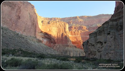
Oh wait, I know why. Because I get to wake up to this:
The sun rises on the Redwall Limestone (click on any pic to enlargenate)
I have brought a journal on this trip of a lifetime, in May 2015, down the Colorado River in Grand Canyon, and I actually write in it:
“Do not sleep well. Too much wine last night and stayed up late talking around the campfire. Still, get up just past dawn, and break my little camp in a morning routine of coffee, breakfast, and teeth brushing at the river. Sunlight reflection off the Redwall in the early morning light is mesmerizing, so is first pic of the day.”
My early May sunrise at the mouth of Saddle Canyon
The hike that had been postponed yesterday is on the agenda for this morning, three miles round trip, up Saddle Canyon to a waterfall. I lace my boots and get ready to rumble up the trail. The guides all wear flip flops. I shake the sand out of my ears and head out in search of ancient river channels embedded within these layered rocks.
Saddle Canyon trail is on the right
Old friends, sharing the trip of a lifetime
“The trail contours up the talus slope, 400’ elevation gain, then levels out, past wild grape, pink monkeyflower, yellow columbine, and native tobacco. As we level out, Jay (one of the flip-flopped guides) points out a Devonian river channel in the opposite wall of the canyon, just below the Redwall.”
Jay points out something on the wall, and I know what it must be.
Devonian river channel nestled within the base of the Redwall
Where? What are we looking at? Oh, wow!
It’s right there!
“Reaching the waterfall involves removing my boots and replacing them with water shoes (courtesy of my sister), wading a narrow shallow stream, and then maneuvering up a narrow, water-slick crevasse. The water drips down moss-covered limestone; we linger in the shade on ledges of chert. Then we do it all in reverse – I hold on to Jay’s arm while backing down the crevasse, to drop first a right foot then left, then both on that step, bend knees, grab hold of a rock knob hidden under a ledge, left then right, then plop down as gracefully as possible onto the water and moss-slickened limestone – all done backwards! We mosey on down the slope to the boats, from the base of the Redwall, past monkeyflower and wild grape and slices of ancient river channels of the Temple Butte Formation.”
Below the Redwall
“Lunch is at the boats. We had packed most of our stuff before the hike and just have blue bags left, for a change of clothes. We are told that our bathing suits will come in handy at the Little Colorado later today.”
Tying down the rigs
Kris considers a beached flotilla of dories that seems to have appeared from nowhere and have no apparent people attached to them. I wonder if this is the same size boat that John Wesley Powell used on his Colorado River expeditions starting back in 1869. It seems unlikely, considering all the food, supplies and scientific instruments he carried (and eventually lost to the rapids). I don’t know for sure, though, and do not think to ask a guide.
Kris considers possibilities
One of the dories
“Then the wind really picks up, and never lets up even after we reach our third night’s campsite. It is relentless – I do not see how oar and paddle boats travel in such wind. We motor into and down the dolomites, limestones, and shales of the Tonto Group in the cold wind and intermittent rain. It is not the most comfortable of conditions.”
Nankoweap Canyon and Rapids
“We go past Nankoweap Canyon in the rain, and peer at distant granaries (and a steep access trail up the slope) built into the side of the cliff.”
A rainy view of the granaries at Nankoweap
Granaries perched in the cliffs
The sky is a fuzzy puzzle of constantly shifting clouds, alternately obscuring the sun overhead then teasing us with patches of blue just beyond the horizon of jagged cliffs. Brrrrr!!! Everyone is huddled together on the boat mattresses, thick with thermal layers and rain gear, but still wet from the rain and chilled from the wind. A plastic tarp does second duty as a lap blanket for those shivering souls in the front of the boat. My feet are freezing in their neoprene socks.
J-rig riders, all bundled up – Kris is smiling on the right
According to my river map and guide, the river has been cutting down through the sloping Bright Angel Shale since shortly after leaving Saddle Canyon. It is at river level at Nankoweap Canyon. Somewhere around Kwagunt Rapid and river mile 56, the Bright Angel Shale and other layers of shallow marine muds become more apparent as I endeavor to figure out the stratigraphy.
Bright Angel Shale shines at river level
BJ expounds while in his Rasta disguise
However, the Bright Angel Shale and its muddy marine relatives slowly retreat from river level. As the oldest, earliest layer of the Tonto Group, the 540-million year old Tapeats Sandstone quietly announces its arrival, and will soon have its own unique story to tell.


