Before the lamb of March turns into the showers of April, there are unanswered questions from my previous post that must be addressed.
1) Will we make it out alive before the amphitheater erodes completely?
2) When exactly does the sun go down over the yardarm?
3) Will we ever put on those skis?

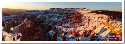
Before we clip our ski boots onto those narrow pointy planks of space–age plastic, though, we talk ourselves into crawling out of our warm beds the next morning at the crack of dark o’thirty. The plan is to watch the sunrise at –you guessed it –Sunrise Point. We hustle out the door after choking down a cup of weak hotel room coffee. Breakfast will have to wait. We have places to go and things to see. The sun is on its way up and it does not hang around on the horizon for long.
 |
| Waiting for the inevitable, Sunrise Point, Bryce Canyon National Park |
 |
| Sunrise gracefully bathes the amphitheater in its light |
 |
| Hoodoos capture the morning light |
There are quite a few other crazy, early riser types out here. A large bus in the parking lot disgorges its consignment of Chinese tourists in light jackets that scurry to view a sight they have come halfway around the world to see. A group of chirpy college students from Virginia laughs and shifts places at the overlook. They are on an “alternative spring break,” cleaning up trails at Bryce and Zion instead of drinking themselves into a coma on the beaches of Cancun. We wait. We marvel at the splendor of the canyon, its hoodoos awash in the burnished gold of a late winter sunrise. We wiggle and squirm to stay warm. We chat and snap pictures for strangers. Others walk down the icy trail into the amphitheater in sneakers. The yellow edge of the sun materializes from beyond the horizon. People cheer. Someone cries “I smell bacon!”
Does the setting half moon mind that it plays second fiddle to the rising sun? Does the sun even care that it has an audience?
 |
| The moon fixes to set behind the amphitheater |
We head for the restaurant and loiter over breakfast, partaking of a second helping of bacon and additional biscuits with jam. Then, since all three of us are so totally exhausted, we go back to our rooms and take a nap at ten o’clock in the morning. The experts on this expedition say it is just too early in the day to ski yet. Besides, for some reason, I am so tired that I can hardly maintain an upright position. I would not do well on skis in this condition. We snooze until early afternoon.
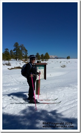
Soon enough, rested and re–fueled with snacks and bad coffee, we re–arrange the car with all the accoutrements of our sport, drive across the street to the trailhead, and commence kicking and gliding out to Fairyland Point. I estimate that the sun is not quite over the yardarm.
 |
| Cross country ski trails outside the Park are groomed by Ruby’s Inn |
 |
| These two are the experts on this expedition |
 |
| I do my best but I’m not very good at skiing. |
 |
| Powell Point comes in to view |
 |
| Sinking Ship is just left of center; Powell Point/Table Cliffs in distance |
At Fairyland Point, we gaze at (and are part of) the Pink Cliffs, the youngest rocks and highest step on the Grand Staircase of southern Utah and northern Arizona. Beyond the nearby Paunsagunt Fault, the Table Cliffs to the east stand nearly 2000 feet higher in elevation than Bryce Canyon, even though they are comprised of the same rocks of the Claron Formation. The Paunsagunt Fault is a normal fault, its hanging wall dropped down to the west due to stretching of the crust during Great Basin extension that started some 30 million years ago during Tertiary times.
Interestingly, it was Clarence Dutton in 1880 that first recognized the Paunsagunt Fault and placed the western boundary of the Colorado Plateau right there. Bryce Canyon and the surrounding high elevation country are considered part of the High Plateaus, a transitional zone between the Colorado Plateau and the Basin & Range Provinces.
 |
| View from Fairyland Point – tilted Sinking Ship is in upper right |
Along with the prominence of Powell Point at the edge of the Table Cliffs, Sinking Ship is another landmark visible from Fairyland Point. The ship is a block of Claron Formation rocks, tilted westward due to drag on the Paunsagunt Fault.
 |
| Beyond the hoodoos – Sinking Ship, the Table Cliffs ,, and Powell Point |
We slowly turn away from the view and soon are back at the car. According to John’s gps, we skied just over two miles. He and Cathy are pros at this, while it is the farthest this girl has ever gone. We do make it back to our hotel across the street before the amphitheater erodes completely. As for when exactly the sun goes down over the yardarm? I have no idea.
 |


