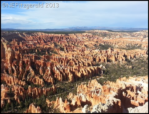
Amid all the rocks eroding off the top of the Paunsagunt and Markagunt Plateaus in southern Utah you will find those of colorful Lake Claron. It is not just any old lake, however. This one happens to be around 50 million years old.
 |
| Brilliantly hued lake bed sediments of Bryce Canyon National Park |
Bryce Canyon National Park and its nearby cousin Cedar Breaks National Monument are part of the most recent reincarnation of that ancient lake. Its surface area has been estimated to have been nearly 18,000 square miles, a bit more than halfway between Lake Erie’s (9,910) and Lake Michigan’s (22,300) size.
It is also estimated to have lasted for some 25 million years, from about 65 million to 40 million years ago.
Great Lakes, indeed.
 |
| Cedar Breaks National Monument |
The grandest staircase of all
You can’t really talk about rocks in southern Utah and northern Arizona without mentioning the Grand Staircase, one of the most distinctive erosional features of sedimentary rocks in the country if not the world. The “high plateaus” of southwestern Utah are at the tippy–top, and the deepest gorges of the Grand Canyon in northern Arizona are at the bottom. As you move north to south from the top to the bottom – across the pink cliffs, the grey cliffs, the white cliffs, the vermillion cliffs, the chocolate cliffs – the rocks become geologically older in time.
 |
| Powell Point on the distant Aquarius Plateau is also composed of Claron Formation rocks |
Bryce Canyon and Cedar Breaks are both part of these high plateaus, with Bryce on the Paunsagunt Plateau and Cedar Breaks on the Markagunt. Their Lake Claron rocks compose the Pink Cliffs, the youngest on the Grand Staircase.

Before there was a lake, there was a sea
Starting around 150 million years ago (give or take a few weeks) the Western Interior Seaway was created as the Farallon tectonic plate plunged or subducted beneath the North American plate. Mountains were uplifted and a huge depression formed in the middle of the continent. Waters from an early Arctic Ocean and Gulf of Mexico flooded into these central lowlands.
 |
| Grey hills just beyond red rocks of Bryce are remnant of the interior seaway |
The seaway advanced and receded over the course of millions of years. At its largest, the Western Interior Seaway was ≈ 600 miles wide. At its deepest, it may have been only ≈ ½ mile deep, shallow in terms of seas.
The rocks of this interior seaway can be seen at the bottom of both Bryce Canyon and Cedar Breaks.
 |
| 1,500 ft below the rim at Cedar Breaks are rocks of the interior seaway |
Mountains, mountains everywhere…
Millions of years passed. Mountain–building continued from 140–35 million years ago, crunching a path up and down the ancient western edge of North America, all the way from Mexico to Canada.
Evidence of two major mountain–building events or orogenies is splattered all over western North America. Mountains created by the earlier event, the Sevier orogeny, are thought to have pierced the sky to over 15,000 feet in height. Mountains created by the later event, the Laramide, are known to us as the Rockies.
Meanwhile, during this geological free–for–all the area where Bryce and Cedar Breaks would ultimately be was uplifted to near its present elevation between 8,000–9,000 feet above sea level. As the landscape was uplifted the interior seaway receded for good.
Meandering streams and rivers flowed sluggishly across the resulting extensive plains of the uplands. Periodic flooding occurred which inundated these plains and spread mud, silt, and cobbles across vast areas. Iron in the mud and silt was rusted or oxidized, turning the soil into hematite and giving its pink and reddish hues.
 |
| Rusted or oxidized sediments of the Claron Formation |
Over still more time an extensive system of shallow lakes spread across parts of what would become Colorado, Wyoming, and Utah. These lakes spread to the Bryce/Cedar Breaks area and lasted from around 65–40 million years ago.
A lot can happen in 25 million years. Lakebed sediments were deposited as surrounding mountains eroded away. Climate cycles of wet and dry days, seasons, decades and millennia caused the lake to expand and shrink through time. And so it happened, as layers of differing thicknesses and composition were left stacked one on top of the other in and almost endless pageant of uplift, deposition, and erosion.
The rocks at Bryce Canyon and Cedar Breaks tell a story of an ancient Lake Claron and its boundaries, from sand and cobbles at its shoreline to oozy, lime–rich mud in the deepest waters. It’s an incomplete story, though; like a brief snapshot taken on your birthday it does not account for the whole of your life.
Be that as it may, it’s an entirely fascinating history even if we never will know the entire tale.


