If I stopped at every road cut I came across I’d never get anything else done.
This is not necessarily a bad thing.
Geological lollygagging in southern Utah can easily become a full–time obsession. More than many other places on the planet the geology here is utterly in your face, unencumbered by pesky vegetation, exposed for the entire world to see if that world would just take a few moments to look a bit more closely.
 |
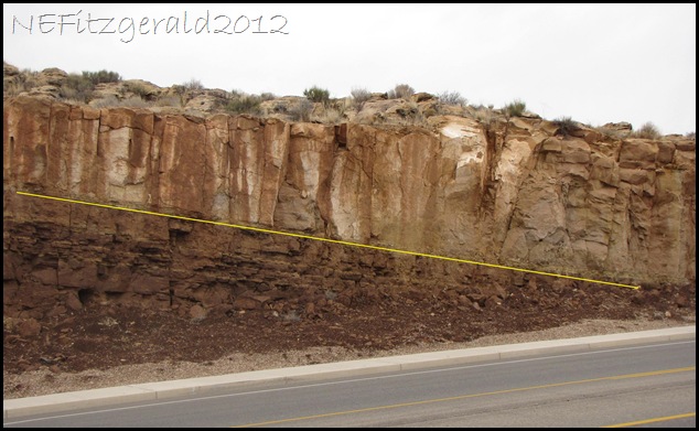
| Tonaquint Drive road cut exposes an unconformable contact between Moenkopi and Shinarump deposits |
I’ve driven by this road cut so many times without stopping that the other day I decided “Enough! Everything else can wait while I poke around.”
 |
| Moenkopi Formation underlies Shinarump Conglomerate on Tonaquint Drive |
Tonaquint Drive in St. George slices nicely through some sheer exposures of the crumbly upper red member of the Early Triassic Moenkopi Formation along with overlying Shinarump sandstone conglomerates of the Late Triassic Chinle Formation. These rocks are prevalent here along the western edge of the Colorado Plateau and can be followed for hundreds of miles into Arizona.
 |
| Yellow line indicates unconformable contact between Moenkopi and Shinarump deposits |
The yellow line in the image above indicates the contact between the two rock formations. There is an unconformity here, an episode of missing geologic time of approximately ten million years, give or take a few weeks.
What happened?
The Seas Come In and the Seas Go Out
Around 245 million years ago during Early Triassic times a shallow sea occupied the western edge of North America. Over the next five million years this shallow sea vacillated back and forth over the edge of the continent until it eventually withdrew. The mudstones, limestones, siltstones, sandstones and shales of the Moenkopi Formation tell this story.
 |
| Moenkopi Formation underlying Shinarump Conglomerate |
Starting at the base of the formation where the older rocks are found (not visible in the road cut – we’re looking at the younger upper part), the different member units of the Moenkopi record an intricate series of shallow marine encroachments and withdrawals. This occurred across a very gently sloping continental shelf. Here, sea level changes of a mere few feet covered a vast shoreline many miles across.
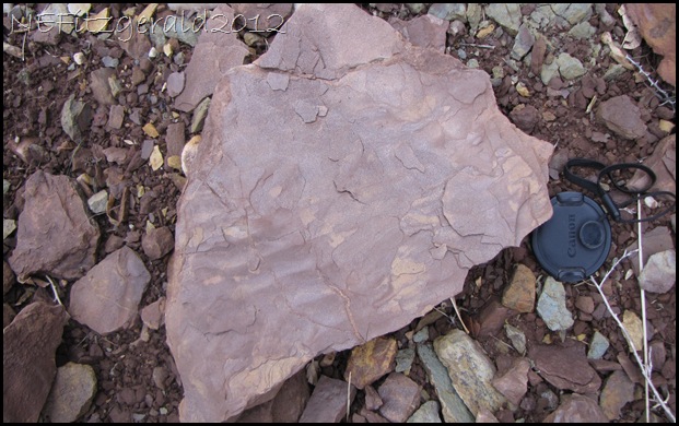
In the upper red member of the Moenkopi we see evidence of the land being exposed above sea level in its many ripple marks, fossil mud cracks, and thinly laminated bedding of mudstones and siltstones. This evidence indicates a seasonal continental climate of wet and dry conditions with sluggish streams moving on a broad, gently–sloping coastal plain or tidal flat.
 |
| Fossil ripple marks |
 |
| Thinly bedded mudstones and siltstones of the Moenkopi Formation |
In the upper red member of the Moenkopi, we see that the sea has finally withdrawn for good, for now.
Return of a Continent
Erosion is much more likely to happen when the landscape is exposed above sea level, and that is what happened as the seas withdrew. For the next ten million years an unconformity developed as streams originating in highlands hundreds of miles distant carried away the upper red sediments of the Moenkopi. Braided streams coursed their way across a landscape of low relief, eventually blanketing an area of some 100,000 square miles with their own load of sands and gravels.
Chunks of the underlying mudstones called rip-up clasts would have been swept up and carried along in the current along with the gravels and sand.
 |
| Yellow arrow points to probable rip-up clasts of underlying mudstone contained in the Shinarump stream deposits |
Now cemented with quartz, these deposits are known as the Shinarump Conglomerate. They form the distinctive light tan ledge or cliff overlying the upper red member of the Moenkopi.
 |
| Fossilized wood fragment in Shinarump Conglomerate |
I’ve often wondered about these braided streams, wondered how the sands and gravels were transported several hundred miles on a gently sloping coastal plain. Wouldn’t the streams have dumped their load closer to their source in the highlands as the grade leveled to a lower relief? One possibility is that the streams coursed across a broad uplift, giving them a higher velocity and allowing them to carry their load of sands and gravels further.
| Yellow arrow points to the fossilized wood fragment |
We can never know everything that occurred 225 million years ago. What we see in the rock record is a snapshot of those events that happened a long time ago. Like a picture taken on your tenth birthday, it is not the whole of your life but merely a brief moment in time.
What these road cuts do is give us an inkling of an episode, a clue to a larger picture whose details have been worn away by the ravages of time. These inklings and clues are what make road cuts so intriguing and surely worth a bit of lollygagging on a back road into town.


