Seven hundred miles in fourteen hours, all in one day. Our two–car caravan just keeps on driving and driving and driving. I’m still reeling from that sweet road marathon and it happened six and a half years ago.
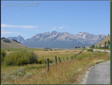
Besides driving and driving and driving, though, we are also stopping and stopping and stopping. We hold the Salmon River Scenic Byway and the Rocky Mountains of western Montana responsible for our inevitable propensity to stop for photo ops.
 |
| Salmon River Scenic Byway |
 |
| Scenic outcrops |
 |
| Salmon River |
I was still a student back then in the summer of 2005, having just finished up the first year in what would turn out to be a five–year quest to obtain a Bachelor of Science degree in geology. It was oh! so easy to convince my two dear friends, JC and CO, to accompany me on an epic road trip to the Canadian Rockies and its Holy Grail of paleontology, the Burgess Shale. I didn’t really know too much of anything about the geology of anywhere back in those days, though. We just sailed like a summer romance through the grandeur of Idaho and Montana high country, trying to stay between the white lines while at the same time knowing that the journey is the destination. From southern Utah to the Canadian Rockies, we would drink in every single mile.
Since JC and CO are nestled together in their own car and I am alone in mine, they are able to relieve each other behind the wheel and also do a lot more of the windshield photography for the trip. The occasional “Rubber Ducky calling California Drivers” on the 2–way radio lets them know that this solo driver needs to pause and refresh.
 |
| Salmon River Scenic Byway |
Miles and miles of nothing but miles and miles, as my father used to say. Without a geologic map to refer to or road guide to guide me I guess my best guess while doing drive–by geology. I speculate that these outcrops here could be igneous or those peaks there could be sedimentary, age and affinity unknown. We pass Slate Creek and so there must be metamorphic rocks too. Hour after hour, near and distant saw–toothed ridges the color of faded russet potatoes roll endlessly past our peripheral vision like a retro revolving lamp. Rounded spires of rocky sunburned jaggedness pierce the hazy August sky as we follow a small platoon of Hot Shot fire–jumper trucks into the town of Salmon, Idaho. Always in search of the ever–elusive picnic table, we find one and pause for a riverside lunch in the cottonwood–shaded coolness of a town park.
 |
| Following the Hot Shots south of Salmon, ID |
 |
| Hot Shots on the highway |
 |
| Picnic spot in Salmon, ID |
Mile after mile after mile continues to roll by. We cross the high lonesomeness of the continental divide and say goodbye to Idaho. Somewhere in the sunny early evening of western Montana JC suggests we drive 100 more miles to Whitefish and spend two nights there. Around the time we concur on this suggestion my air conditioner gives up the ghost. We are along the western border of Flathead Lake, a shimmering sheet of sapphire blue vastness edged by mountains resembling so many crumpled brown rugs.
It is dusk by the time we check into the KOA near Whitefish, and at these summer latitudes dusk does not come early. JC springs for the wine – make that two bottles, please! We have come seven hundred miles in fourteen hours and I for one am totally hammered. With a picnic table at our disposal we prepare our dinner and sip our wine, once again watching as the late evening sunlight slowly fades from the western sky, dusk turn to inky darkness, and the stars come out to play.
The next morning I am the first to awaken and take the indisputably prize–winning photo of the entire trip.


