I was the first person to wake up the morning we were supposed to hike out for our overnighter in the Valley. Of course it had rained all night, and was still raining. Should we have expected anything else? It was nowhere near a pounding thunderstorm (never raining hard enough, for instance, to choke a toad), but was just an Alaskan rain – a soft, light, steady drizzle through low gray clouds that obscured the surrounding mountain peaks. The diffuseness of the light kind of made my head ache and I thought “Oh jeez – I don’t want to start out hiking in this weather.”
Starting a hike in the rain can be a real downer. My personal philosophy regarding this phenomenon is that starting a hike in sunshine is much better for morale. If the weather deteriorates from there, well, at least there was some sunshine to be had for a while. But if the hike starts in the rain, is seems certain that for some reason it will stay raining forever. I’m just saying.
So we procrastinated for as long as possible (“We could stay here and play cards all day…”). I was not the only one with less than the highest amount of enthusiasm for setting out in the rain. But we finally got motivated. We had to get motivated – the Valley tour bus was due any moment and we had to vacate the visitor center by the time they arrived. OK! Everything goes into the back room as quickly as possible! Pick up the sleeping bags and stove and water bottles, sweep the floor and wipe the tables and they will never know we had been there!
So we had barely gotten our stuff moved when the bus drove past the window. Oooh, busted!!! OK – decision time – we’d go hiking for the day to the 5-mile camp site and back. We’d hike down the low mountain from the visitor center into the 98-year-old Novarupta ash flow where there would be one river crossing across Windy Creek, and then the walking would be easy, around the base of the Buttress Range for a while and along River Lethe. There was a good enough trail – yay!!! A trail in Alaska!!! My dreams have come true at last. And we’d be able to catch a ride back to Brooks Camp that evening.
Coming down off the mountain the trail passed through some serious foliage and mucky tundra. The trail was easy enough to follow, though, and there were long views into the misty cloud-shrouded Valley. I wondered how hammered I would be at the end of the hike (I was totally hammered) and how miserably tired I would be climbing up out of the Valley after 11 miles (I was definitely tired but nowhere near miserable) if it was still raining (it most certainly was raining). There was a narrow run-off stream to jump before crossing Windy Creek, and then a quick climb up the river bank put us on our way into the Valley proper. Woo Hoo!!!
At the fumaroles
Pumice from the 1912 Novarupta explosion was everywhere on the Valley floor – rhyolitic, andesitic, and banded pumice in every conceivable combination. Gray-black and rusty orange discolorations in the ground were evidence of the fumaroles or “steam plumes” that had occurred in the floor of the Valley – the ash flow was thought to have been at temperatures of up to 2000 degrees F, searing the lush green Valley and turning groundwater into steam which curled upwards in columns of 500 feet or more (Robert Griggs, in a 1916 expedition to the Valley, thought there was a huge magma chamber beneath the Valley and that the steam plumes were “emanations” from this subterranean magma). The fumaroles had ceased their steaming activity by the 1930’s.
River Lethe and the Three Amigas
Hiking along River Lethe
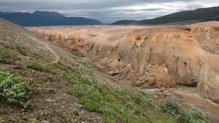
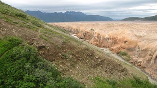
The trail wound toward and then along the base of the Buttress Range and soon we were walking beside the deep, narrow canyon that the River Lethe is relentlessly cutting through the ash. Blocks of ash from the nearly 100-foot canyon walls are eroding away as the river winds this way and that, eventually working its way down to bedrock and some semblance of its original pre-eruption course, on its way to the Savonoski River and eventually out to the Bering Sea.
Lunch spot

Views from lunch spot

Lunch was at the 5-mile campsite beneath a cascade of clear water dropping from high off the Buttress Range (I filled my water bottle and drank from it, and a week later I am fine so I guess there was little enough bear, beaver, or moose poop present to cause me grief). We enjoyed lovely warming sunshine for about 30 minutes while we ate and from then on the misty drizzly rain continued as our intermittent companion for the rest of the hike. The Young Hikers wanted to go on further and explore, but this old girl explained that my total hiking distance would end up being 11 miles by the time we returned to the visitor center (5 mile campsite was actually 5 and ½ miles according to Steve’s gps) and so, familiar as I am with my personal limits, I would be starting back. Jeanette was gracious enough to go back with me while Steve and Jacqui would explore and catch up with us later.
Have you ever noticed how the hike back usually seems shorter than the hike out? Jeanette and I even took our time and stopped for some photo ops. Before I knew it we were tracking away from River Lethe and pointing our boots across the flat ash terrain toward the crossing at Windy Creek. Here we temporarily replaced our boots once again with sandals and, using our poles as support, forded the thigh-deep swiftly-moving creek. We sat in the wet sand to put our boots back on (we were wearing rain pants – we could sit anywhere!) and then continued on our way, up the low, thickly vegetated, seriously rain-drenched mountain and back to the visitor center.
I was soaked to the bone, totally chilled, and really, really tired.
But the Valley is worth it and I can’t wait to get out there again.
Canyon of River Lethe


