So much to see in the Anchorage area, and so little time to see it. These posts are dated a little funnily (or funny, or funny-like, you choose), since I am on Alaska time which is 2 hours earlier than Mountain time. When I was writing my post for Tues. 4/27, it showed up as Wed. 4/28 UNTIL I changed my computer clock to AK time. I address these issues and then soon all is well in the world. Now we match.
Day-tripping on the Seward Scenic Highway along Turnagain Arm of Cook Inlet took up the better part of an on-again, off-again overcast south-central Alaska late April afternoon. The weather was jacket-cool as I arrived at Potter Marsh, south of town, for some as-serious-as-I-could-manage bird watching. I had my binoculars around my neck and my camera on a tripod. That is so special!

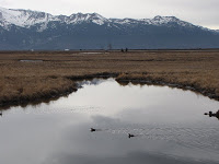

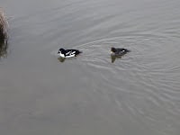
The highlight of my few hours at the marsh were the pairs of goldeneyes who kept dipping and popping as they fed in the water. The black and white of the male was stunning.
In the distance, the snow-capped peaks of the Kenai Mountains and those of Chugach State Park and National Forest bled a white background into the gray overcast of the late morning. Often just a barely visible dark thread of contrast distinguished mountain from sky. Walking the entire boardwalk took up probably about a mile and a half, round trip. I took it slow and enjoyed just being in this particular time and space.
I soon continued driving south, operating under the hopeful assumption that the sky would be a bit clearer later in the afternoon. So I didn’t stop at too many viewpoints, instead choosing to drive onward to wherever it was I found myself next. The beluga whale is found in Turnagain Arm and is endangered. There is a place to watch for them at the mouth of Turnagain but I thought it was too early in the season to see them so I didn’t stop.
These sculptures of the whale are a surprise at Bird Point, though – 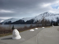
Eventually I realized I hadn’t eaten for around 5 hours, and so thought that Girdwood, about 40 miles or so from Anchorage, would be a good lunch stop and turn-around point.
The Hotel Alyeska is perched on the side of a valley above Girdwood. My lunch was nice but nothing special. I was the only person in the restaurant besides the waiter. I am not an architect, but I had the distinct feeling that someone was channeling Frank Lloyd Wright when they re-designed the property, with lots of slatted wood accents, wide staircases, and art deco-style carpeting. Very chi-chi and too spendy for my pockets.
This is more in my price range –> 
OK – now for some action! The clouds had cleared, sort of. I figured it was about as clear as I could expect for Alaska. We’re not in Utah anymore, Toto.
I had earlier seen some road cuts that just begged me to stop and investigate on the return trip. I needed to get out of this drive-by geology mode! There were tons of pull-offs and scenic viewpoints – except where signs stated “Avalanche Area – No Stopping For The Next 2 Miles.” Those mountainsides were steep, and I could see avalanche chutes of various configurations zig-zagging their gravitational way down the slopes.
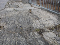
The rocks along the highway road cuts definitely looked like phyllite, a metamorphic rock which probably at some time in the distant past had been a sedimentary mudstone or siltstone. That sheen! That foliation! I was in heaven. At Bird Point the phyllite appeared to have been scoured by the last glaciers to have passed this way.
Can you see the glacial striations? Imagine standing under moving ice a couple miles thick and having it scrape off the top of YOUR head —
Alaska is Alaska because of plate tectonics and subduction of the denser Pacific oceanic plate under the less dense North American continental plate. The mountain ranges that inspire such awe in humans consist of accreted terranes, various size land masses that have been rafted along on the Pacific plate and collided with what was in its way when it met this part of North America.
Much of the rock along the Seward Scenic Highway is part of the Valdez Group, believed by some to have been deformed and accreted to the continent by latest Cretaceous age (maybe 80-70 million years ago). Others believe the accretion continued for some time later, into the Tertiary. The rafted land mass was deformed by faulting and metamorphosed by heat and pressure as it underwent subduction and subsequent uplift into the mountains we see today in south-central Alaska.
OMG!!! My non-geology friends are probably ready to shoot me! But you all know by now that I really can’t help myself.
Back to some pictures —
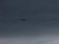
My favorite stop along Turnagain Arm was Bird Point – I spotted 2 bald eagles in addition to being surrounded by phyllite.
This pic REALLY IS a bald eagle. That wing span is magnificent.
FACTOID: Turnagain Arm of Cook Inlet has the 2nd greatest difference between high and low tides in the world.
Huge amounts of silt from Cook Inlet and the Susitna River are brought in on the stronger incoming tide; when the tide goes out again, the silt is dropped as sediment.
When I was driving in, the tide was going out.
When I was driving out, the tide was coming in.
Beautiful, either way.


